![]()

![]()
1. Geography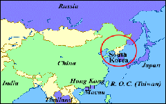 The Korean Peninsula extends for about 1,000 kilometers southward from the
northeast part of the Asian continent and consists of the Korean Peninsula and
over 3,400 islands. The peninsula and all of its associated islands lie between
33°N and 43°N parallels and 124°E and 132°E meridians. The northernmost point is Yupojin in Onsong-gun, North Hamgyong Province, and the southernmost point is
Marado Island, Cheju Province. The westernmost point is Maando Island in
Yongchon-gun, North Pyongan Province, and the easternmost is Tokdo Islets in
Ullunggun, North Kyongsang Province. The standard meridian of the peninsula is
135°E, so Seoul local time is nine hours ahead of Greenwich Mean Time.
The Korean Peninsula extends for about 1,000 kilometers southward from the
northeast part of the Asian continent and consists of the Korean Peninsula and
over 3,400 islands. The peninsula and all of its associated islands lie between
33°N and 43°N parallels and 124°E and 132°E meridians. The northernmost point is Yupojin in Onsong-gun, North Hamgyong Province, and the southernmost point is
Marado Island, Cheju Province. The westernmost point is Maando Island in
Yongchon-gun, North Pyongan Province, and the easternmost is Tokdo Islets in
Ullunggun, North Kyongsang Province. The standard meridian of the peninsula is
135°E, so Seoul local time is nine hours ahead of Greenwich Mean Time. The Amnok (Yalu) River and the Tuman (Tumen) River border both China and Russia to the north and Japan is just across the East Sea. Since 1945, as a byproduct of the Cold War, the peninsula has been divided at the 38th parallel into the Republic of Korea, or South Korea, and the Democratic People's Republic of Korea, more commonly known as North Korea. Lacking formidable land or sea barriers along its borders and occupying a central position among East Asian nations, the Korean Peninsula has served as a cultural bridge between the mainland and the Japanese archipelago. Korea contributed greatly to the development of Japan by transmitting both Indian Buddhist and Chinese Confucian culture, art, and religion. The total area of the peninsula is 221,607 square kilometers, similar in size to that of the U.K, New Zealand, or Romania. South Korea possesses 99,237 square kilometers or 45% of the total landmass, while North Korea 122,370 square kilometers, the remaining 55%. 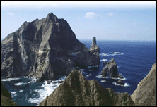 Korea has
a varied terrain, though about 70 percent of the territory is mountainous. The
spectacular Mountains Taebaek run the full length of the east coast, where the
lashing tides of the East sea, have carved out sheer cliffs and rocky islets.
The western and southern slopes are very gentle, forming plains and many
offshore islands honeycombed with inlets. Korea has
a varied terrain, though about 70 percent of the territory is mountainous. The
spectacular Mountains Taebaek run the full length of the east coast, where the
lashing tides of the East sea, have carved out sheer cliffs and rocky islets.
The western and southern slopes are very gentle, forming plains and many
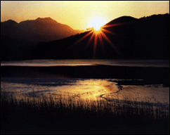
offshore islands honeycombed with inlets. The peninsula has many scenic mountains and rivers, so Koreans often call it the "land decorated with golden embroidery." The highest peak is Mt. Paektusan, or the Ever White Mountain, which stands 2,744 meters high on the northern borderline facing Manchuria. South Korea's highest peak is Mount Halla (1950 meters) in Cheju Province. Most of the larger rivers are located in the west and have their tributaries on the north and east sides, and flow into the Yellow Sea and the South Sea. In South Korea, the Naktong River and the Han River are the two major rivers responsible for irrigation and industrial water supply. The Han River flows through Seoul, the capital of the Republic and serves as a lifeline for the large population in the central region, including Seoul's 11 million residents. The river also played a significant part in the development of Korea's ancient civilization. Surrounding the peninsula on three sides, the sea has played a remarkable role in Korean life since ancient times, contributing to the early development of shipbuilding and navigation skills. The coastline is dotted with bays and it has some of the highest tides in the world. The eastern coastline has many sandy beaches, while the western side consists mainly of mud flats and rocky shores. Off the southern coast, more than 3,000 islands of various sizes are scattered and provide beautiful scenery unparalleled in the world. |
|
2. Climate and Weather
|
 Part of the East Asian monsoon
region, South Korea has a temperate climate with four distinct seasons:
spring, summer, autumn and winter. Winters are usually long, cold, and dry,
whereas summers are short, hot, and humid.
Part of the East Asian monsoon
region, South Korea has a temperate climate with four distinct seasons:
spring, summer, autumn and winter. Winters are usually long, cold, and dry,
whereas summers are short, hot, and humid. 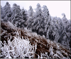 Temperatures range from a low of -15°C
in winter to a high of 34.7°C in summer. Seoul's mean temperature in January
is -5°C to - 2.5°C; in July the mean temperature is about 22.5°C to 25°C.
Because of its southern location, Cheju Island has warmer and milder weather
than other parts of South Korea. Mean temperatures on Cheju range from 2.5°C
in January to 25°C in July.
Temperatures range from a low of -15°C
in winter to a high of 34.7°C in summer. Seoul's mean temperature in January
is -5°C to - 2.5°C; in July the mean temperature is about 22.5°C to 25°C.
Because of its southern location, Cheju Island has warmer and milder weather
than other parts of South Korea. Mean temperatures on Cheju range from 2.5°C
in January to 25°C in July.
![]()
![]()